
The 10 best hiking routes in the Balearic Islands
Looking for the best hiking trails in the Balearic Islands? This article brings together 10 outstanding options for discovering incredible landscapes, from mountains to hidden coves. Here's a summary:
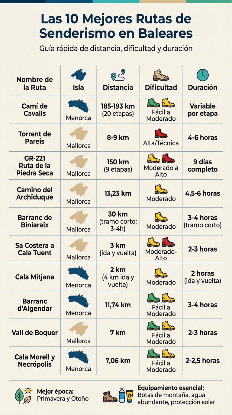
- Camí de Cavalls (Menorca): 185 km divided into 20 sections that circle the island. Ideal for all levels.
- Torrent de Pareis (Mallorca): A technical 8 km route through a stunning gorge. Experience required.
- GR-221 Dry Stone Route (Mallorca): 150 km through the Serra de Tramuntana , with options for shelters.
- Archduke's Way (Mallorca): 13 km circuit from Valldemossa with views of the Mediterranean.
- Barranc de Biniaraix (Mallorca): Cobbled path with Arab history, perfect for spring and autumn.
- Sa Costera to Cala Tuent (Mallorca): Mountain route ending in a quiet cove.
- Cala Mitjana (Menorca): Short walk from Cala Galdana to a paradise beach.
- Barranc d'Algendar (Menorca): Shaded route that connects Ferreries with Cala Galdana.
- Vall de Boquer (Mallorca): 7 km walk to a virgin cove with views of Formentor.
- Cala Morell and Necropolis (Menorca): Combines prehistoric history with coastal landscapes.
Key tip: Visit in spring or autumn to avoid high temperatures and enjoy each route well-prepared with water, appropriate footwear, and sun protection. Discover the Balearic Islands' natural beauty!
The 10 best hiking routes in the Balearic Islands: distance, difficulty and duration
The most EPIC route in Palma de Mallorca "GR221"
1. Camí de Cavalls (Menorca)
The Camí de Cavalls is a historic route that hugs the Menorcan coast for approximately 185-193 km, following an ancient 13th-century defensive path. The best part is that you don't need to complete it all at once, as it's divided into 20 independent stages, suitable for different fitness levels and available time.
Difficulty level
This route is ideal for both beginners and more experienced hikers. If you're looking for something easy, try the sections in the S'Albufera des Grau Natural Park . For a moderate challenge, choose the 11 km between Cala Galdana and Santo Tomás. Although the terrain is mostly flat, some sections have loose stones, so be sure to wear appropriate footwear.
Distance and duration
Each stage offers a unique experience. For example, the Es Grau – Favàritx section covers 8.61 km and combines wetlands with coastal views. On the other hand, Cala Morell – Punta Nati is a 7.06 km stretch of cliffs and includes a visit to a prehistoric necropolis. Many prefer to explore specific stages rather than complete the entire circuit.
Natural and historical characteristics
The Camí de Cavalls will take you through spectacular landscapes steeped in history. You'll discover wetlands teeming with birds in S'Albufera des Grau, cliffs covered in Mediterranean vegetation such as mastic trees and junipers, and pristine coves with crystal-clear waters like Mitjana and Trebaluguer. The lighthouses of Favàritx and Punta Nati are also noteworthy, while the Cala Morell necropolis connects you to the island's first inhabitants.
Local tips
Water is a limited resource in many sections, so bring more than you think you'll need and take advantage of the coastal towns to refill your supplies. If you start in Maó, consider skipping the first 6 km of asphalt with no shoulder and begin directly in Sa Mesquida. Menorca, being less crowded than Mallorca, offers a more tranquil experience even in peak season. To avoid the heat, start your walks early and choose to travel in spring or autumn. This route is just one example of how the Balearic Islands combine history and nature on their trails.
2. Torrent de Pareis (Mallorca)
The Torrent de Pareis is one of Mallorca's most challenging and spectacular routes. This 3.3 km long gorge has been sculpted over thousands of years by water erosion. From the heights of the Serra de Tramuntana mountains, the canyon descends to meet the Mediterranean Sea, flanked by limestone walls that reach up to 300 meters in height .
Difficulty level
This route is known for its high difficulty , making it a challenge even for experienced hikers. The trail requires descending technical sections, scrambling over rocks, and maintaining balance on uneven terrain. Therefore, excellent physical fitness and prior mountaineering experience are essential. If you are a beginner, it is best to opt for the company of a professional guide or someone who knows the area well. It is no coincidence that the Torrent de Pareis accounts for nearly 25% of mountain rescues in Mallorca.
Distance and duration
The entire route, from Escorca to Sa Calobra, is 8–9 km long with an elevation gain of 650 meters . It is estimated to take between 4 and 6 hours to complete. As it is a linear route, planning your transport is essential. A practical option is to leave a car in Escorca (km 25.2 of the Ma-10 road) and take the ferry from Sa Calobra back to Port de Sóller.
Natural and historical characteristics
The route begins at S'Entreforc , where the Torrent de Lluc and the Torrent des Gorg Blau meet. As you continue, you'll pass through Sa Fosca , a section so narrow that it barely allows sunlight to penetrate, and through the "Pas des Grassos Estrenyeu-vos," a narrow passage between rocks. This canyon is home to more than 300 plant species, 10% of which are unique to the Balearic Islands. It is also home to the ferreret , a midwife toad native to Mallorca. The route culminates at Sa Calobra beach, famous for its crystal-clear waters and imposing cliffs.
Local tips
Avoid this route if it has rained or rain is forecast , as the limestone rocks become extremely slippery and the risk of flash floods increases considerably. Wear sturdy hiking boots with good traction, and for the more challenging sections, consider carrying a 10-meter rope. It's also essential to bring 2–3 liters of water and energy snacks , as the natural springs are not always safe to drink. Start early to avoid the midday heat and make sure you reach Sa Calobra before the last boat. The best time to hike the Torrent de Pareis is between May and October, when the riverbed is usually dry. Mallorca has much more to offer, and this route is just the beginning of its natural wonders.
3. GR-221 Dry Stone Route (Mallorca)
The GR-221, known as the Dry Stone Route , is much more than just a footpath: it's a journey through Mallorcan history and traditions. This route crosses the Serra de Tramuntana mountain range, a UNESCO World Heritage Site recognized for its cultural landscape. Along the way, the dry stone constructions stand out, a traditional technique that has shaped walls, terraces, and paths, reflecting centuries of craftsmanship and human effort. Like other routes in the Balearic Islands, this one blends spectacular nature with a fascinating historical legacy.
Difficulty level
The difficulty of the GR-221 varies depending on the stage you choose. Some sections are moderate, but others, such as the stage between Sóller and Son Amer, can be quite demanding, with 2,000 meters of accumulated elevation gain and 30 kilometers of trail. Appropriate hiking boots are essential, as the terrain includes loose stones and slopes that require good stability and grip.
Distance and duration
The main route connects Port d'Andratx with Port de Pollença over 150.1 km, divided into 9 stages. However, if you include the 7 official variants, such as the routes to Galatzó or Castell d'Alaró, the complete network reaches 261.1 km. Most hikers complete the main route in about 9 days, reaching its highest point at the Coll de ses Cases de Neu, at an altitude of 1,200 meters.
Natural and historical characteristics
This route is a feast for the senses. From breathtaking coastal views to high mountain landscapes, passing through oak forests and typical Mediterranean scrubland, the route offers a unique variety of scenery. You'll also find historical remains, traditional architecture, and places steeped in local legends. Each stage is an opportunity to immerse yourself in Mallorca's rich past and natural diversity. This combination of elements makes every kilometer unforgettable.
Local tips
To fully enjoy the GR-221, it's important to stick to the officially marked sections, as some are still under development. If you decide to explore the University variant from Esporles, you can take advantage of the frequent metro service from the UIB (University of the Balearic Islands) to return comfortably to Palma. Although the Mediterranean climate allows you to hike the route almost year-round, it's advisable to book mountain refuges in advance, especially during peak season, to guarantee your accommodation.
4. Archduke's Way (Mallorca)
The Archduke's Path is one of Mallorca's most famous trails, renowned for both its history and breathtaking views. It was designed in the late 19th century by Archduke Ludwig Salvator of Austria , who created a path that winds along the high ridges of the Serra de Tramuntana mountain range. This circular route begins and ends in the charming village of Valldemossa, offering unparalleled panoramic views of the Mediterranean and the surrounding mountains. Here are the key details to help you make the most of this experience.
Difficulty level
The trail is classified as moderately difficult , although some hikers note that the initial section, from Valldemossa to the Can Costa viewpoint, can be somewhat challenging. The steady climb and rocky terrain require good physical condition and appropriate footwear to avoid slipping.
Distance and duration
The standard route is a 13.23 km circuit with a total elevation gain of 672 meters . There is also a shorter option, which passes through Ses Fontanelles and the Camí de ses Bases, with a length of 8.44 km and an elevation gain of 581 meters . Depending on your pace, the complete route can take between 4.5 and 6 hours.
Natural and historical characteristics
One of the highlights is the Can Costa viewpoint , which offers spectacular views of both the Mediterranean and the Serra de Tramuntana mountain range, a UNESCO World Heritage Site. Furthermore, the path retains sections of the original paving, a testament to the 19th-century construction skills.
Practical tips
To park in Valldemossa, a good option is to look on Calle els Olivers , where you can usually find spaces near the trailhead in Son Gual Petit. It's advisable to start early, especially in summer, as the mountain areas are very sunny and lack shade. Bring plenty of water and food, as there are no facilities once you're at higher altitudes. Also, check the weather forecast before setting out, as reduced visibility or strong winds in the higher areas can make the hike dangerous.
With a score of 4.9 out of 5 stars on Wikiloc and a TrailRank of 96/100 , this route is a favorite among hiking enthusiasts in Mallorca.
5. Barranc de Biniaraix (Mallorca)
The Barranc de Biniaraix is a trail that follows an ancient Moorish road, connecting Sóller with the Tramuntana mountains. This gorge, with its iconic dry-stone path and centuries-old agricultural terraces, reflects the historical legacy and traditional land use of Mallorca. Here's the essential information about this route.
Difficulty level
The route is of moderate difficulty, although those unaccustomed to hiking in mountainous terrain might find it challenging. The cobbled path, with its uneven and rocky surface, requires constant attention and appropriate footwear to avoid accidents.
Distance and duration
As part of the GR-221 long-distance trail, the full stretch between Sóller and Son Amer covers 30 km . However, many choose to hike only the initial section, which can be completed in about 3-4 hours round trip. This shorter route offers breathtaking views of the valleys and peaks of the Tramuntana mountains.
Natural and historical characteristics
This trail traverses a landscape declared a World Heritage Site by UNESCO. Along the way, natural springs, dry-stone constructions, and agricultural terraces offer an enriching experience, both visually and historically. The original layout of the Moorish road adds a unique touch to this route, making it a true immersion into the past.
Local advice
Spring and autumn are the ideal seasons to explore the Biniaraix Ravine. During these times, the springs are flowing and the vegetation is at its peak, creating an incomparable setting. In contrast, summer can be challenging due to high temperatures and a lack of shade along much of the route.
To begin the route, the best option is to head to the small village of Biniaraix, located 3 km from Sóller. There you'll find a few parking spaces near the trailhead. It's advisable to arrive early, especially on weekends, as space is limited. This practical tip ensures you can fully enjoy the experience this unique corner of Mallorca has to offer.
6. Sa Costera from Ses Barques to Cala Tuent (Mallorca)
Sa Costera de Ses Barques is a route that connects the mountain road with the tranquil Cala Tuent , a pebble beach nestled in the Serra de Tramuntana mountain range. This trail is notable for its spectacular views of the Mediterranean and for winding between cliffs covered in typical local vegetation, where the sea and mountain landscapes intertwine in a unique way. It is one of the many natural gems that Mallorca has to offer.
Difficulty level
The route is of moderate to high difficulty, mainly due to the steep incline and rocky terrain. The descent requires good physical condition and knee stability, while the ascent, especially in the sun, can be quite demanding. Hiking boots with good grip are essential, as loose stones can make the terrain slippery.
Distance and duration
The round trip is 3 km long and takes about 2-3 hours to complete, depending on your pace and breaks. The total elevation gain is approximately 200 meters , mainly concentrated on the return leg from the cove.
Natural and historical characteristics
This trail crosses the Serra de Tramuntana mountain range, a UNESCO World Heritage Site. During the descent, you'll walk through oak forests and Mediterranean vegetation, with breathtaking views of the cliffs and the northern coast of Mallorca. Cala Tuent, at the end of the trail, is a pebble beach surrounded by mountains, perfect for a refreshing dip before heading back.
Local advice
Parking on the Ma-10 road, near the trailhead, is limited, so it's advisable to arrive early, especially between May and September. There's no mobile phone coverage in this area, so be sure to download the route track beforehand. Spring and autumn are the best times to hike this trail, as temperatures are milder and the climb is less strenuous. Bring plenty of water, as there are no water sources along the way.
sbb-itb-2b14d48
7. Cala Mitjana (Menorca)
Cala Mitjana is one of Menorca's natural gems, renowned for its unspoiled beauty and incredible photogenic appeal. It's accessed via a trail that forms part of the historic Camí de Cavalls ( GR-223 ) , connecting with Cala Galdana . This route, which winds through lush Mediterranean pine forests, offers spectacular views of turquoise waters and reddish cliffs. At the end of the trail, a dreamlike white sand beach awaits. It's an experience that combines exercise, history, and the reward of a swim in a truly idyllic setting.
Difficulty level
The route is of moderate difficulty, making it accessible to people with a basic level of fitness. However, there are sections with loose stones and slight inclines, so it's important to wear appropriate hiking boots that offer good grip.
Distance and duration
The route from Cala Galdana to Cala Mitjana is about 2 kilometers and can be completed in approximately 1 hour at a leisurely pace. If you decide to extend your adventure to Santo Tomás following the Camí de Cavalls, the total distance will be 11 kilometers . In total, the round trip to Cala Mitjana takes around 2 hours .
Natural and historical characteristics
This section of the Camí de Cavalls has a historical origin dating back to the 13th century, during the reign of James II. As you walk along the path, you'll be accompanied by the sounds of summer, such as the chirping of cicadas, while you pass through cool Mediterranean pine forests that offer natural shade. Upon reaching Cala Mitjana, the view is breathtaking: crystal-clear waters of a brilliant turquoise blue, white sand, and a setting surrounded by cliffs and native vegetation. It's a place where the feeling of being immersed in nature is absolute.
Local advice
To fully enjoy the experience, it's best to start your hike early in the morning , avoiding the intense heat and crowds. Although Menorca is quieter compared to Mallorca or Ibiza, Cala Mitjana can get crowded during peak season, especially in July and August. Bring plenty of water and some light snacks, such as nuts or fruit, to keep your energy up. Of course, don't forget your swimsuit and a towel for a refreshing dip when you arrive. And very importantly: take all your trash with you and respect this unique natural environment.
8. Barranc d'Algendar (Menorca)
The Barranc d'Algendar is a corner of Menorca's interior that stands out for its natural charm. Far from the typical coastal routes, this ravine offers a cool, shady environment that connects the town of Ferreries with the popular Cala Galdana . It's a perfect option for those looking to explore the greener, more tranquil side of the island. Here are the details you need to plan your visit.
Difficulty level
The route is of easy to moderate difficulty, with a positive elevation gain of only 181 meters . This makes it a suitable option for most hikers, as the paths are well-marked and do not present any significant technical challenges.
Distance and duration
The route is 11.74 kilometers long and takes about 3 to 4 hours to complete. It is important to bring enough water, as there are no water sources along the way.
Natural and historical characteristics
The Barranc d'Algendar is considered one of the most impressive landscapes in the interior of Menorca. As you walk, you'll be surrounded by imposing rock walls covered in native vegetation, providing shade and a cool atmosphere, ideal for escaping the heat of the coastal routes. It's also a unique opportunity to observe Mediterranean flora and, with a bit of luck, spot birds of prey that inhabit the cliffs.
Although the ravine doesn't have any major archaeological remains, walking through this area is a way to connect with the island's history, once inhabited by Phoenicians, Carthaginians, and Romans. The landscape has probably not changed much since then, which adds a special touch to the experience.
Local advice
The route, which begins in Ferreries and ends in Cala Galdana , offers a spectacular coastal finish. This order is ideal for enjoying idyllic views at the end of the hike. According to Wikiloc, the route has a rating of 5.0/5 and a TrailRank of 97/100 , being described as "stunning" and "peaceful."
To avoid the heat, especially in summer, it's recommended to start early in the morning. Don't forget to take all your trash with you to preserve this unique natural environment.
9. Vall de Boquer (Mallorca)
The Vall de Boquer is one of those magical corners of the Serra de Tramuntana mountains that you simply can't miss. Located near Pollença, this route takes you from an inland valley to a pristine cove surrounded by breathtaking cliffs. Two rock formations mark the start of the trail and promise an unforgettable experience.
Difficulty level
This route is suitable for hikers of all levels. The path is well-marked and presents no major technical difficulties. However, the final stretch to the cove can be somewhat uneven and rocky, so appropriate hiking boots are essential for safety.
Distance and duration
The route covers 7 kilometers and takes about 2 to 3 hours to complete. It's a relaxed hike that allows you to enjoy the scenery at your own pace. On Wikiloc, the route has a 5/5 rating, with many praising its pristine condition and spectacular views.
Natural and historical characteristics
Along the way, you'll come across the Casas de Bóquer , 17th-century buildings offering incredible views of Pollença Bay and Mount Cavall Bernat . Further on, at Coll des Moro , a natural viewpoint offers panoramic views of Cape Formentor and the peculiar "Ull de Bou" (Bull's Eye), a natural hole in the rock.
If you take a slight detour after passing the initial rock formations, you can explore the Talayotic settlement of Bocchoris , a historic site with stone terraces that reflect human presence since ancient times. Furthermore, about 500 meters from the rocky pass, you'll find the Font del Sementer , a hidden spring perfect for refreshing yourself before continuing.
Local advice
To begin the route, park in the parking area at the second roundabout on the Ma-2200 road, coming from Pollença. Look for the wooden sign indicating "Camí de Bóquer", located near a SYP supermarket. Note that the path crosses a private property with two gates that you must close after passing through.
If you're traveling with children, avoid summer, as the high temperatures can make the hike difficult. Winter is ideal for enjoying this area in all its splendor. At Coll des Moro , take the path furthest to the right for a safer descent to the cove and better views. Finally, a curious detail: local goats often approach visitors looking for food. Don't be surprised if you have unexpected company on the beach!
10. Cala Morell and Necropolis (Menorca)
We continue exploring the archaeological and scenic treasures of Menorca with a route that combines prehistoric history and spectacular coastal views. The Cala Morell Necropolis is one of the island's most outstanding burial sites, with 14 artificial caves carved into the cliffs of the ravine. From this point begins Stage 9 of the GR-223 (Camí de Cavalls) , which leads to the Punta Nati lighthouse, traversing impressive cliffs along the coast.
Difficulty level
The route is classified as easy to moderate , as it has no steep inclines and requires no advanced technical skills. However, the rocky terrain can be challenging, so hiking boots with good grip are essential. Shoes with thin soles are not recommended, as they do not offer the necessary stability.
Distance and duration
The complete route, from Cala Morell to Punta Nati, is 7.06 kilometers long, with a total elevation gain of 104 meters , and takes approximately 2–2.5 hours to complete. On Wikiloc, this route has an excellent rating of 5/5 and a TrailRank of 96/100 , standing out for its photogenic views and clear signage.
Natural and historical characteristics
The first 30 minutes of the route run along the edge of the cliffs, offering spectacular sea views. Afterward, the path leads to a natural viewpoint. The Necropolis , dating back to the pre-Talayotic period, deserves at least 40 minutes to explore its ancient burial caves. Meanwhile, Cala Morell , measuring 80 meters long by 50 meters wide , is perfect for a quick dip. Although it has little sand, access to the water is easy via concrete platforms.
Local advice
Park in the open area near the cove and arrive early, as it fills up quickly during peak season. Take some time at the beginning of the walk to explore the Necropolis, which is free to enter. At the end of the route, don't miss the area around the Punta Nati lighthouse. Bring plenty of water and some food, as there are no facilities along the way. In the inland areas, the lack of shade makes sun protection essential. If you enjoy snorkeling, the crystal-clear waters of Cala Morell are ideal for observing its rich marine life.
Practical Tips for Hiking in the Balearic Islands
Accompany each route with these general recommendations to make your hiking experience in the Balearic Islands unforgettable.
Spring and autumn are the ideal seasons to visit the Balearic Islands, thanks to their pleasant temperatures that avoid the extreme heat of summer. As Carlos Sanagustín of Mallorca Free Tour says:
"Spring and autumn are the best seasons for hiking in Mallorca, as the temperatures are more pleasant."
Summer, on the other hand, is more suitable for technical routes such as the Torrent de Pareis, when the riverbed remains dry between June and September.
The right gear makes all the difference on these hikes. Hiking boots with good grip are essential, as many trails have rocky terrain with limestone and loose stones. Opt for lightweight, breathable clothing on coastal routes, but bring a windproof jacket if you plan to venture into the Tramuntana mountains, where the wind can be strong. Don't forget to pack plenty of water and sun protection , especially on the sunniest routes.
Check if you need permits for your route . For example, at Muntanya del Voltor (Valldemossa), a free permit must be obtained in advance, while at Puig de Massanella, there is a €6 entrance fee. Additionally, some areas have seasonal restrictions : the cliffs may be closed from March 1st to August 31st to protect nesting birds.
Protect the natural environment by staying on marked trails to avoid damaging the soil. Always follow the "leave no trace" principle: take your trash with you and pick up any litter you find. Before setting out, check the weather forecast , as conditions can change unexpectedly. By following these guidelines, you can enjoy each route to the fullest and without any problems.
Conclusion
Imagine an archipelago where every path is a gateway to history, nature, and breathtaking views. From the historic Camí de Cavalls to the spectacular Archduke's Path , each route reveals the soul of the Serra de Tramuntana and its surroundings. Here you'll find stunning canyons and coastal trails that seem designed to awaken your sense of adventure. Every step on these routes connects you to the Balearic Islands' past, amidst dry stone walls and seascapes that tell centuries-old stories.
The options are as varied as the landscape itself. You can explore canyons like the imposing Torrent de Pareis , with walls up to 200 meters high, or enjoy peaceful walks along the coast, perfect for combining hiking with a swim in hidden coves. In Menorca alone, there are more than 640 routes available, making the Balearic Islands a must-visit destination for hiking enthusiasts, regardless of their experience level.
So, lace up your boots, choose the route that inspires you most, and plan your trip for spring or autumn to fully enjoy it. Download the GPS tracks of your favorite routes and get ready for an experience that will take you to the heart of the Mediterranean. Connect with the pure essence of these islands and let yourself be swept away by their natural magic.
FAQs
What is the ideal time to enjoy hiking in the Balearic Islands?
The ideal seasons for hiking in the Balearic Islands are spring and autumn . During these months, the weather is mild and pleasant, allowing you to walk without suffering from the high temperatures of summer or the cold of winter. In spring, the landscape bursts into color thanks to the blossoming flowers, while autumn offers a cool and peaceful atmosphere, with fewer tourists on the trails.
While summer is also an option for some, the heat can make hiking more challenging. Therefore, it's crucial to avoid the hottest hours of the day and carry plenty of water to stay hydrated. For a more enjoyable and safe experience, it's best to choose routes in spring or autumn, when nature is at its most beautiful.
What experience is needed to do the Torrent de Pareis route?
The Torrent de Pareis is one of those routes that leaves a lasting impression, but it's not for everyone. It's a challenge reserved for experienced hikers , as it combines uneven terrain, technical sections, and physical exertion. A thirst for adventure isn't enough; you need preparation and solid mountaineering knowledge.
If you decide to tackle this route, it's best to do so with someone who already knows it. Having a guide or an experienced companion can make all the difference. Also, don't forget something crucial: always check the weather conditions before setting off . Rain or humidity can turn this route into a real hazard.
Is it necessary to book accommodation in the shelters along the Dry Stone Route?
No, you don't need to make a reservation to stay in the shelters along the Dry Stone Route. However, there's something important to keep in mind: some sections of this route are still under development or lack signage, which might complicate your trip planning.
To make the most of this experience, it's best to check the current condition of the route before you start. It's also very helpful to carry an up-to-date map and be prepared for possible changes to your itinerary. This will help you enjoy the trip without any problems.