
GR10 vs GR11 vs HRP: Key Differences
Wondering what the best route is to cross the Pyrenees? Here's a quick summary:
- GR10 : The French route, at 882 km, is known for its humid climate, green landscapes, and excellent network of accommodations. Ideal for those seeking comfort and good signage.
- GR11 : The Spanish side, at 850 km, offers a drier climate and higher altitude passes. Perfect for hikers with some experience who value easy access to villages and mountain huts.
- HRP : At 750 km, it is the most challenging, traversing high mountain peaks. It requires advanced navigation skills, autonomy, and experience in technical terrain.
Which one to choose? The GR10 is more accessible, the GR11 combines adventure and logistics, and the HRP is for experienced mountaineers. Read on for more details and to decide which one is right for you.
Comparison GR10 vs GR11 vs HRP: Trans-Pyrenean Routes
Pyrenees Mountains Hiking Documentary (GR10 - HRP - GR11)
sbb-itb-2b14d48
What is GR10?
The GR10 is the French trans-Pyrenean route that traverses the entire mountain range along its northern slopes , connecting Hendaye on the Atlantic coast with Banyuls-sur-Mer on the Mediterranean. This route, which is usually divided into 42 to 47 stages depending on the guidebook, reaches its highest point at the Col de Madamète at 2,509 meters , although if you choose to climb Canigou, you can reach 2,784 meters . The trail began to be marked in the 1960s and was fully signposted in 1975. Below, we explore its main features and some of the highlights of this route.
Main features of the GR10
The GR10 is known for its excellent network of accommodations , including gîtes d'étape , mountain refuges, and hotels, allowing hikers to complete the route without carrying camping equipment. The influence of the Atlantic climate on the northern slopes creates lush, green landscapes.
The route is perfectly marked with the classic white and red blazes , making navigation easy along the entire way. Although the altitudes are generally lower than those of the HRP, the GR10 remains a demanding physical challenge due to its constant steep ascents and descents. The speed record is held by Pascal Blanc, who completed the route in an impressive 10 days, 20 hours, and 25 minutes on August 4, 2019.
Highlights of the GR10
The GR10 is not only a physical challenge, but also an enriching experience thanks to its unique natural and historical sites. Among the most emblematic landmarks are the Pic du Canigou (2,784 m), the Chemin de la Mâture , an ancient path carved into the rock face of a cliff, and the Holtzarte footbridge , which offers spectacular views as it crosses a deep gorge. In addition, towns like Saint-Jean-Pied-de-Port , Cauterets , Luz-Saint-Sauveur , and Bagnères-de-Luchon are ideal stops for resting and resupplying.
The route also crosses the Pyrenees National Park , passing highlights such as the Col d'Ayous , famous for its views of the iconic Midi d'Ossau, and the Hourquette d'Arre . Along the way, hikers enjoy a mix of landscapes including coastlines, verdant valleys, high-mountain lakes like Lac de Gaube , and breathtaking peaks, making the GR10 a comprehensive experience for discovering the French side of the Pyrenees.
What is GR11?
The GR11, one of the most iconic routes in the Pyrenees, runs along the southern slopes of this mountain range, connecting Cape Higuer on the Cantabrian coast with Cap de Creus on the Mediterranean. Stretching between 835 and 850 kilometers and with a cumulative elevation gain of approximately 42,000 meters, this trail traverses some of Spain's most breathtaking landscapes, such as Ordesa y Monte Perdido National Park , Posets-Maladeta Natural Park , and Aigüestortes i Estany de Sant Maurici National Park . Although most of the route lies within Spain, it also passes through Andorra and small sections of France. Below, we review its main characteristics and highlights.
Main features of the GR11
The GR11 is divided into 46 stages and crosses mountain passes that reach altitudes of between 2,500 and 2,700 meters in its central section. The route is marked with the characteristic white and red blazes of the GR system, although in high mountain areas it is advisable to carry a GPS or detailed maps for greater safety.
Unlike the GR10, which runs along the northern slopes, the GR11 offers a drier and more stable climate during the summer, with a Mediterranean character that reduces rainfall. Furthermore, it boasts an excellent network of mountain huts, hostels, and accommodations in nearby villages, simplifying logistics compared to more demanding routes like the HRP. Although designed for experienced hikers in good physical condition, some stages are accessible to those with less mountain experience.
GR11 Highlights
The GR11 is not only a well-marked and equipped trail, but also a route filled with spectacular scenery. Among the highlights is Ordesa y Monte Perdido National Park, famous for its deep canyons and limestone cliffs. In this area, the Góriz refuge is a strategic location for exploring the Monte Perdido massif. Other must-see spots include Aguas Tuertas, a high-mountain valley with a river winding through meadows, and the Circo de Pineta, known for its impressive glacial waterfalls. Also noteworthy is the Picos del Infierno area, near Panticosa, with its distinctive marble ridges.
In Catalonia, the trail crosses the Aran Valley and the Aigüestortes i Estany de Sant Maurici National Park, famous for its numerous ibones, or high-mountain lakes. Further on, it passes through the Vall de Núria, a mountain sanctuary accessible only on foot or by rack railway, and culminates at Cap de Creus, where the Pyrenees meet the Mediterranean. This combination of alpine landscapes, deep valleys, and peaks exceeding 3,000 meters makes the GR11 an unforgettable adventure for those wishing to explore the Spanish side of the Pyrenees.
What is HRP (Haute Randonnée Pyrénéenne)?
The HRP, or Haute Randonnée Pyrénéenne, represents the greatest challenge in the Pyrenees, following the ridgeline of this mountain range. Unlike the GR10 and GR11 trails, the HRP is not an official or marked route , but rather a conceptual high-mountain trek that stays as close as possible to the border between France and Spain, constantly crossing back and forth. With a route of approximately 800 kilometers and a cumulative elevation gain of around 44,000 meters, the traverse is usually divided into 44 or 45 stages, requiring between 5 and 7 weeks to complete.
What makes the HRP unique is its mountaineering focus, rather than its hiking focus. Brian Johnson, an expert on Pyrenean routes, describes it this way:
The HRP... is not so much a hike as a mountaineering expedition... and you should expect to get lost!
Approximately 20% of the route is off-trail, requiring the use of GPS, maps, and excellent navigation skills. Furthermore, the route maintains high altitudes, between 2,000 and 3,300 meters, crossing 23 mountain passes above 2,500 meters , compared to 12 on the GR11 and only 2 on the GR10.
Main features of the HRP
The HRP is technically demanding, with terrain that includes scree slopes, banked fields, and passes requiring scrambling , demanding mountaineering skills. Kelly Floro, editor of The Trek , describes it as:
The HRP is the only route that follows the spine of the mountain range as closely as possible from one end to the other through a complex network of roads, trails, and sometimes no trail at all.
.
Logistics are a major challenge. Stops in towns are infrequent, forcing hikers to carry provisions for several days and rely on camping or bivouacking. One mountaineer recounted spending 32 days without passing a single food shop , depending on mountain huts for occasional meals. Essential equipment includes a lightweight, four-season tent and a sleeping bag with a thermal comfort rating of at least -5°C, as nights can be very cold even in summer.
At the beginning of summer or in years with heavy snowfall, the HRP requires winter mountaineering skills , such as the use of ice axes and crampons. The ideal time to attempt it without specialized snow equipment is from July to September.
With these characteristics, let's see who is prepared to face this challenge.
Who should do the HRP?
Given its demanding nature, the HRP is intended exclusively for experienced mountaineers who are self-sufficient, comfortable in high-altitude environments, and possess solid navigation skills. It is not suitable for beginners or those seeking routes with frequent accommodations. Ross McGibbon warns on the UKC forums:
The HRP tends to climb high and stay high. The GR trails are designed to reach a base valley each night, so there seem to be more ascents and descents.
.
The ideal candidate includes prior high-altitude mountaineering experience, the ability to manage emergencies in remote environments, and excellent physical condition. A resilient mindset is also key, as weather conditions can change rapidly, with afternoon thunderstorms and significant temperature swings. For those who meet these requirements, the HRP offers a pure mountain experience, with stunning alpine lakes and a sense of isolation and adventure that no other route in the Pyrenees can match.
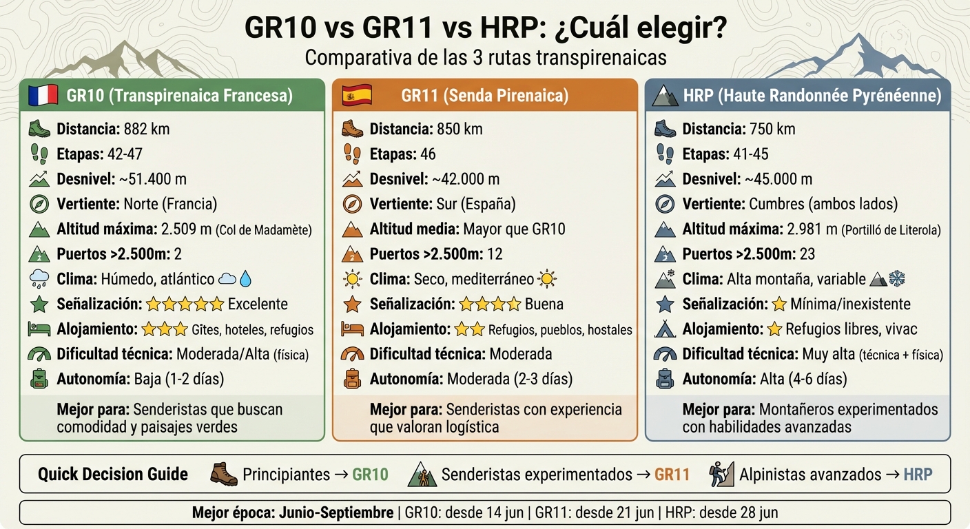
Comparative table: GR10 vs GR11 vs HRP
Here's a detailed comparison of the three most popular Pyrenean routes: GR10, GR11, and HRP. This table will help you quickly identify which one best suits your needs and experience level.
| Feature | GR10 (French Transpyrenean) | GR11 (Pyrenean Trail) | HRP (High Pyrenean Route) |
|---|---|---|---|
| Total distance | ~882 km | ~850 km | ~750 km |
| Number of stages | 42–47 | 46 | 41 |
| Total elevation gain | ~51,400 m | ~42,000 m | ~45,000 m |
| Slope | North (France) | South (Spain) | Summits on both sides |
| Difficulty | Moderate/High (physical) | Moderate | Very high (technical/physical) |
| Signaling | Excellent (red/white) | Good (red/white) | Minimal/non-existent |
| Climate | Humid, Atlantic, more rain | Dry, Mediterranean/alpine | High mountain, variable |
| Infrastructure | High-end (gîtes, hotels, shelters) | High (villages, shelters) | Low (few services) |
| Accommodation | Staffed shelters, gîtes d'étape, hotels | Staffed shelters, hostels, rural hotels | Free shelters, bivouacs |
| Required autonomy | Low/Moderate | Moderate | High (4–6 days between resupplies) |
| Best time | June–September | June–September | July–September |
| Recommended profile | Fit hikers seeking green landscapes | Hikers who value good logistics | Advanced mountaineers |
The GR10 is characterized by being the longest route with the greatest elevation gain, posing a significant physical challenge. On the other hand, the GR11 offers an ideal balance between adventure and accessibility, as it crosses numerous mountain villages where accommodation and services are readily available. In contrast, the HRP is the option for those seeking a more extreme experience: it requires advanced technical skills, significant autonomy, and the ability to navigate in high-altitude conditions.
Signage is another key aspect. According to Carles from Mendiak.net , the GR10 has impeccable signage , while the GR11 is also well-marked along most of its sections. However, the HRP lacks official signage , relying instead on stone cairns that can be difficult to locate, especially in adverse conditions. This makes the HRP an ideal option for those proficient in using GPS and maps, a departure from the conventional hiking offered by the other two routes.
Later on, we will analyze in depth the differences in landscapes, infrastructure, technical difficulty and the overall experience that each route provides.
Key differences between GR10, GR11 and HRP
Although all three routes cross the Pyrenees from coast to coast, each offers a completely different experience. Understanding these differences will help you choose the trek that best suits your fitness level, expectations, and the type of adventure you're looking for.
Landscape and climate
The GR10 trail runs along the northern slopes of the Pyrenees, known for its lush, green landscapes. Beech and oak forests, alpine meadows, and deep glacial valleys predominate here. Due to northwesterly winds, this French side receives more rain and cloud cover than the Spanish side. Furthermore, it rarely exceeds 2,500 meters in altitude and crosses only two high mountain passes.
In contrast, the GR11 follows the southern slopes, which are drier and sunnier. This side of the Pyrenees offers higher and more rugged terrain, with granite and limestone peaks and a greater presence of bare rock, especially towards the Mediterranean. Along its route, it crosses 12 mountain passes above 2,500 meters. However, although drier, this side is prone to thunderstorms that tend to develop slowly and appear in the afternoon or evening.
The HRP , meanwhile, follows the ridgeline, offering a high-mountain experience. With 23 passes exceeding 2,500 meters, this route is renowned for its breathtaking scenery: mountain ridges, glacial lakes, and vast boulder fields. These characteristics also contribute to the route's technical difficulty.
Technical difficulty
In terms of technical difficulty, the routes vary considerably. The GR10 is physically demanding, but technically it is the most accessible. Although it involves a significant elevation change due to the constant descents into valleys and subsequent ascents, it follows well-marked trails and does not require advanced climbing or navigation skills.
The GR11 offers an intermediate level of difficulty. Its average altitude is higher than that of the GR10, and it features more uneven terrain, with boulder fields, scree slopes, and some easy scrambles. Although it is well-marked with red and white blazes, some sections require greater attention and experience.
The HRP is undoubtedly the most technically complex. As Brian Johnson comments:
The route is not signposted... and you should expect to get lost!
It demands advanced skills such as scrambling, GPS navigation, and map and compass use, even in foggy conditions. Furthermore, before the end of June, some high passes may require the use of ice axes and crampons. Lee Wood, an HRP trekker, describes it this way:
The HRP presents a greater challenge in cargo transport, technical difficulty, logistics and navigation
.
Apart from the physical difficulty, the availability of services and access to the routes are key factors to consider.
Infrastructure and access
The GR10 is the route with the best infrastructure. It is fully signposted and offers a wide range of accommodation options: hotels, gîtes d'étape (rural guesthouses on the French side), hostels, and mountain refuges. Villages are frequent, allowing you to resupply every 1-2 days.
The GR11 also has straightforward logistics. Stages typically connect villages, mountain huts, or hostels. Furthermore, most municipalities along the route offer access to campsites, hotels, and guesthouses. While the infrastructure isn't as extensive as on the GR10, it's still sufficient for most hikers.
The HRP , on the other hand, requires greater self-sufficiency. The mountain huts along the route offer limited services, so camping and carrying supplies for up to six days are necessary. Furthermore, there is no official signage, demanding advanced navigation skills and the use of GPS. This lack of infrastructure makes the experience much more challenging, reserved for those with extensive high-altitude mountaineering experience.
Which one to choose based on your profile?
With the differences in technique and infrastructure now clear, it's time to select the route that best suits your abilities and expectations. Each option is designed for a different type of hiker, and knowing yourself will be key to fully enjoying this experience in the Pyrenees.
For beginners
If you're new to hiking or it's your first long-distance trek, the GR10 is the ideal choice. Brian Johnson, an expert on Pyrenean routes, describes it as:
The GR10 – the easiest, oldest and most popular of these routes – remains in France and stays north of the border.
This route is clearly marked with red and white blazes, eliminating the stress of navigation. Its proximity to villages also makes it easy to resupply every 1-2 days and allows for a lighter pack. While technically the most accessible, don't underestimate its physical demands: the constant elevation changes can be challenging. It's the perfect option for a relaxed and enjoyable hike.
For hikers with experience in high mountain terrain
If you already have experience and are looking for a greater challenge, the GR11 is for you. This route combines technical difficulty with relatively easy logistics. With 12 mountain passes exceeding 2,500 meters , the GR11 takes you to higher altitudes than the GR10, traversing varied terrain such as boulder fields and scree slopes. Although well-marked, it requires greater attention and physical stamina. As mentioned in the comparison, it has mountain huts and villages at regular intervals, but some stages are long and camping will occasionally be necessary. If you're looking for adventure with a degree of safety, this is your route.
For mountaineers with advanced skills
The HRP is a traverse designed exclusively for experienced mountaineers. Brian Johnson warns:
The HRP... is not so much a hike as a mountaineering expedition
and adds:
you should expect to get lost
This route is unmarked and requires advanced GPS navigation skills, map and compass use, as well as descent proficiency. With 23 mountain passes exceeding 2,500 meters and a maximum altitude of 2,981 meters at the Portilló de Literola, ice axe and crampons are essential if attempting the route before the end of June. You must be self-sufficient for up to six consecutive days , carrying all camping equipment and supplies. It is an extreme experience for those seeking an uncompromising challenge.
Can GR10, GR11 and HRP be combined?
Yes, it is possible to combine them, and it's not uncommon for experienced hikers to do so to design a customized traverse of the Pyrenees. The HRP acts as a natural bridge between the GR10 (on the northern slopes) and the GR11 (on the southern slopes), regularly crossing the border and sharing sections with both trails at various points.
Strategic planning is essential to making the most of this combination. You can alternate between the marked GR sections and the high-mountain sections of the HRP depending on your needs, whether for logistical reasons or weather conditions. This flexibility allows you to adjust your route if the weather worsens or if you need to resupply. For example, the GR10 and GR11 provide easy access to towns like Gavarnie, Parzán, or Vielha, where you can find supplies, while the HRP crosses more remote areas where you might go days without services.
An interesting case is the HRP 2x3000 expedition, undertaken in September 2016 by Pau Calado. On this 19-day traverse, he linked the most distant 3,000-meter peaks (from Balaitús to Pica d'Estats). Although he primarily followed the HRP trail due to its mountaineering nature, he used sections of the GR11 trail, such as Sallent de Gállego at the beginning and Arinsal (Andorra) at the end, in addition to descending to villages like Gavarnie and Parzán to resupply.
To plan a route that combines these options, digital tools like Mapy.cz are very useful for plotting the route and downloading offline maps, especially in areas where the HRP is not marked. You can also rely on specialized guides, such as those from Cicerone or the French TopoGuides, which detail the points where the routes intersect or run alongside each other.
Remember that on the HRP , advanced navigation skills are essential, as you'll be following stone cairns instead of the red and white markings of the GR trails. Also, be aware of the camping rules: bivouacking (pitching your tent at dusk and taking it down at dawn) is generally permitted, but there are restrictions in national parks like Ordesa.
In the next section, we'll explore how to manage logistics and accommodation to make your trip a success.
Accommodation and logistics on each route
Accommodation availability and logistics vary considerably between the GR10, GR11, and HRP, directly impacting the level of self-sufficiency required. The GR10 boasts the most extensive and developed network: a high concentration of gîtes d'étapes , staffed mountain huts, and hotels along its 882 kilometers. This infrastructure allows for route planning without worrying about long stretches without access to supplies. According to Brian Johnson, the frequent passages through villages and the presence of accommodations like gîtes d'étapes and mountain huts make resupplying on the GR10 straightforward.
In the case of the GR11 , although it is also well-equipped, the infrastructure is somewhat more limited. In certain sections, the lower density of accommodations may require you to plan longer stages or look for rural hotels. Furthermore, staffed mountain huts usually close during the first two weeks of October. Prices are around €20–25 per night for a bed, with dinners costing an additional €20–25. It is important to carry cash, as many huts do not accept cards.
On the other hand, the HRP is the most remote route and presents the greatest logistical challenges. Here you will rely primarily on unstaffed mountain huts, some staffed huts, and, in many cases, camping. Since there are few resupply points, it is essential to carry enough provisions for several days. In some cases, you could go up to 32 days without finding a food store. The main resupply points are Gavarnie, Parzán, and Vielha, where you should stock up on food for 4–6 days.
Each route also requires different strategies for obtaining supplies. Both the GR10 and GR11 pass through villages frequently, allowing you to buy food almost daily. However, the HRP, being in high mountain and remote areas, requires carrying approximately 4 kg of food between resupply points. In Andorra, you'll find a good network of free mountain huts with bunk beds and fireplaces, although you should only use them in emergencies unless you know they are well-maintained.
Here is a comparison table summarizing the key differences in accommodation and resupply:
| Feature | GR10 (France) | GR11 (Spain/Andorra) | HRP (High Route) |
|---|---|---|---|
| Main accommodation | Gîtes d'étape, staffed shelters, hotels | Staffed shelters, rural hotels | Staffed/unstaffed shelters, camping |
| Replenishment frequency | Very high (towns almost daily) | High (regular visits to towns) | Low (remote high mountain areas) |
| Recommendation to bring a tent | Optional | Recommended for greater flexibility | Essential most of the time |
| Shelter price (bed) | Variable | €20–25/night | €20–25/night (subject to availability) |
These logistical factors are key to deciding which route best suits your needs and travel style.
Best time for each route
The best time to hike these routes is from mid-June to September. However, each route has its own specific characteristics depending on altitude and orientation. For example, the GR10 is accessible without crampons from June 14th, the GR11 from June 21st, and the HRP not before June 28th. This is due to persistent snow on the high passes, especially on the French side and on the HRP.
In September, many experienced hikers agree that it's the best month to tackle these routes. Temperatures in the higher elevations range from 6 to 14°C, visibility improves, and mountain huts are usually less crowded. However, this month also brings a greater risk of heavy rain, strong winds, and early snowfall, especially in the far east, near Pica d'Estats. As mountaineer Pau Calado describes it:
Doing it in September... we had some very aggressive rain with a lot of wind and a bit of snow and cold in the last few days
.
From October to May, it's best to avoid high mountain sections. During this period, winter conditions, with snow and ice, are common, and most staffed mountain huts remain closed. According to Cicerone Press:
Trying to complete the entire GR10 in October would be very ambitious and should not be attempted by anyone without experience in snow and winter weather
If your plan is to only visit the lower sections, such as those in the Basque Country, May and October could be viable months, as the temperatures are more moderate.
In July and August, temperatures in the Spanish valleys can reach 37–38 °C, and thunderstorms are common, especially in the afternoons after 4:00 PM. To minimize risks, it is advisable to start your day at dawn and cross the high mountain passes before midday. If you decide to begin your trek before mid-July, don't forget to bring crampons and an ice axe for sections where snow may remain.
With these recommendations, you can plan your adventure in the Pyrenees more safely and enjoy every stage to the fullest.
Conclusion
Deciding between the GR10, GR11, or HRP will depend on your experience level, fitness level, and the type of adventure you're looking for in the Pyrenees. The GR10 is perfect if you prefer lush, green landscapes, with the added benefit of an excellent network of gîtes d'étape ( mountain lodges) and clear trail markings. The GR11 , on the other hand, combines challenge with accessibility, featuring well-distributed mountain huts and nearby villages to simplify logistics. The HRP , however, is designed for experienced mountaineers seeking maximum altitudes and routes without official trail markings.
If you're a beginner, it's best to opt for sections of the GR10 or GR11, where the signage and services will offer greater peace of mind. In contrast, the HRP requires advanced technical skills, such as GPS navigation and map reading. For those seeking the ultimate challenge, completing the three routes—known as the Pyrenean Triple Crown —involves covering 2,480 km and tackling a cumulative elevation gain of 132,000 meters.
With these options clear, all that's left is to choose the one that best suits you. Make sure to plan well, bring the right equipment, and select the best time for your adventure. The Pyrenees await you with spectacular landscapes, exciting challenges, and the promise of an unforgettable experience.
Ready for your Pyrenean crossing? Start planning your route, book your accommodations, and organize all the logistical details. It's time to embark on one of the greatest hiking adventures in Europe!